Rainwater harvesting through multi-tier step pond through community initiative
Rainwater harvesting through multi-tier step pond through community initiative
Problem
The Chhotonagpur range continues in the west of West Bengal. Here the topography is undulated. The top of the mounds are completely barren without any vegetation whatsoever. Here the soil is rocky lateritic with very low water retention capacity. Annual rainfall varies between 1200 to 1400 mm, but the entire rain falls within a period of 2 months in a year. The rest of the year is absolutely dry that gives rise to a drought-like situation. The entire semi-arid region is a single cropped area which is entirely dependent on rain. No crop can be grown in the rest 8 – 9 months due to absence of water. The only rainfed crop is also getting disturbed by the recent erratic changes in the climate.
Most of the lands are thus left unutilized for a very long period. Scarcity of food forces the able-bodied men and women to migrate to neighboring resourceful districts in search of work.
Excavation of pond is a difficult and costly exercise due to the almost impenetrable rocks. So the ponds are usually very shallow and they cannot hold enough rainwater to continue till summer. The wells also get dried up. Some of the rivers have water for 10 – 12 months, but the poor tribals lack resources and knowledge to utilize this water for irrigation during the dry months.
Intervention
- Small and marginal farmers are organized into groups and are motivated to excavate
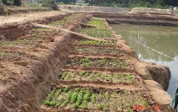
 new ponds and re-excavate old ones. The ponds have a three or four tier design. Three or four broad steps are made on all four sides to reach the centre. These steps remain submerged during the rains. Apart from the rainwater directly falling in the pond, trenches are made to channel the run-off from the adjacent plots to the pond. From the bank on all four sides, trellis is made hanging over the pond for supporting creepers yielding vegetables like pumpkin, bottle gourd, bitter gourd etc. In the dry months, when the level of water in the pond falls, vegetables are grown on the broad steps of the pond. The pond bank is utilized for growing different vegetables, pulse crops like pigeon pea and seasonal, semi-perennial, perennial and multi-purpose trees. Fish is grown in the pond for additional income. Water stored in the pond is utilized for irrigating fallows on both sides of it for growing a wide variety of vegetables. Cultivation on the steps, pond bank and fields is done organically. After assessing the total need of the group, yields from the pond, pond bank and newly cultivated fallows is equally shared among the members of the group. A portion from the remaining harvest is then distributed free among the villagers beyond the group. After this, the surplus is sold in the market and the sale proceeds are deposited in the group’s bank account.
 - Arrangements are made so that the land owner doing a single rainfed crop gives the seasonal fallow to a group of small and marginal farmers for utilization during the dry period. A low cost model has been developed to lift the water from the river for irrigation.
- The pond is of size 1.3 acre; 180ft X 160ft X 10ft.
- The land where the pond is excavated, belongs to 5 persons, who agreed to give the land on lease to 30 farmers. After the lease period is over the pond, it will be retuned to the owners but the water can be used by the farmer’s group.
Impact
- Hitherto unutilized natural resources (fallows) could be made useful for growing food-fodder-fuel.
- Many more person days could be created which, in turn, could reduce the trend of seasonal migration. It has created 2979 man days for pond excavation and 831 man days for mixed cropping in the fallow land.
- Soil fertility could be enhanced.
- Supply of food and nutrition for the family could be ensured throughout the year. Apart from cultivation in the pond bank, it has potentiality to irrigate 10 acres of fallow land. In 2006, as many as 40 types of vegetables were cultivated through mixed cropping.
- Possibility for generating income from selling surplus after own consumption could be opened up.
Source: DRCSC
Last Modified : 3/1/2020
This topic covers the information related to Comme...
This topic provides information about Captive rear...
This topic provides information about the Converge...
This topic provides information about improved pla...
