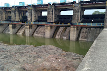
Hatnur dam
Overview of the dam
 Hatnur dam is constructed on the Hatnur river in Tapi River Basin.
- It is situated at Hatnur, Taluka Bhusawal, District Jalgaon, Maharashtra. It is one of the biggest dams of Maharashtra
- The dam was constructed in 1982.
- The dam is meant for irrigation, power generation, water supply and flood control.
- Maximum height above the lowest point of foundation is 25.50 m.
- Length of top of this dam is 2580 m.
- The reservoir has gross storage capacity of 388.00 Mm3.
- It is an earthfill dam.
- This dam has catchment area of 29430 square km.
- It has Ogee type spillway with 41Nos. gates.
- The size of each gate is 12m x 6.50m.
- This dam can pass flood of 26415 cumecs.
- Central Water Commission (CWC) issues in inflow forecast for Hathnur Dam which helps State govt. authority in reservoir operations.
Tapi river basin
- Tapi basin is situated in the northern part of the Deccan Plateau. The basin extends over states of Madhya Pradesh, Maharashtra and Gujarat.
- Extends over an area of 65,145 km with a maximum length and width of 534 & 196 km.
- The basin lies between east longitudes of 72º 38' to 78º 17' and north latitudes of 20º 5' to 22º 3'.
- It is bounded on the north by the Satpura range, on the east by the Mahadeo hills, on the south by the Ajanta range and the Satmala hills and on the west by the Arabian Sea. Bounded on the three sides by the hill ranges.
- The culturable area of the basin is about 4.29 Mha.
- The forest cover is about 25% of the area in the basin.
- Physiographically, the area is a basaltic landscape with major physiographic units of plateau lands, escarpments, hills, piedmont plains, colluvio-alluvial plains and valley plains.
- The entire Tapi basin can be divided in three sub-basins: Upper Tapi Basin up to Hathnur [confluence of Purna with the main Tapi (29,430 sq. km)], Middle Tapi Basin from Hathnur up to the Gidhade gauging site (25,320 sq. km), and Lower Tapi Basin from the Gidhade gauging site up to the sea (10,395 sq. km). The annual rainfall for the upper, middle, and lower Tapi basins for an average year is 935.55 mm, 631.5 mm, and 1,042.33 mm respectively.
- For more information, click here
Related Resources
Last Modified : 8/5/2021
© C–DAC.All content appearing on the vikaspedia portal is through collaborative effort of vikaspedia and its partners.We encourage you to use and share the content in a respectful and fair manner. Please leave all source links intact and adhere to applicable copyright and intellectual property guidelines and laws.
RELATED ITEMS
