Spring Water Atlas
Spring Water Atlas
About Spring Water Atlas
The Spring Water Atlas is a repository of information on springs in the form of science behind the springs, springsheds and springscape. The GIS enabled Online inventory of springs will help in mapping of springs, analyzing their health status, quality of water, discharge capacity and other physical, chemical and biological properties. The portal will strengthen various aspects of springs management to address water scarcity in India.
It is an initiative of the Ministry of Tribal Affairs and United National Development Programme (UNDP).
Overview of Springs
The human habitations in the mountainous regions of India are dominantly dependant on springs for drinking water, domestic usage and agricultural needs. Springs are the lifeline of water supplies for these regions. They have been called different names in different parts of India; “Zhara” in Maharashtra or “Jhora” in West Bengal, “Dhara” in Sikkim or “Naula” or “Baori” in Himachal Pradesh and Uttarakhand, “Kuiphir” in Mizoram or “Ephut” in Manipur, “Chhimik” in Leh-Ladakh and Jharna in Odisha. Springs also form important cultural and religious symbols for humans, with many spring sites being places of worship and prayer. Springs play a vital role in providing ecosystem services in the form of base flows, which feed many small and large rivers, sustain some of the important wetlands and help balance the dry season stocks in many lakes. Springs are points on the Earth’s surface through which groundwater emerges and flows. Most springs are discharged from aquifers, a system of rocks/rock material, which stores and transmits water to such springs and to wells.
Natural factors like climate and seismic activity affect spring discharge. Anthropogenic factors like increasing demand due to rise in resident population and surge in tourist inflow is putting huge pressures on mountain aquifer systems. Ecological degradation associated with land use – land cover change, especially for infrastructure development are shrinking the natural recharge areas of the springs and leading to deterioration in spring-water quality. It is reported that half of the perennial springs have already dried up or have become seasonal, resulting in acute water shortage for drinking and other domestic purposes, across hundreds of Himalayan villages. A continuing crisis of spring water depletion will consequently affect lives of millions of people in the mountains – both resident and visitors.
Springshed
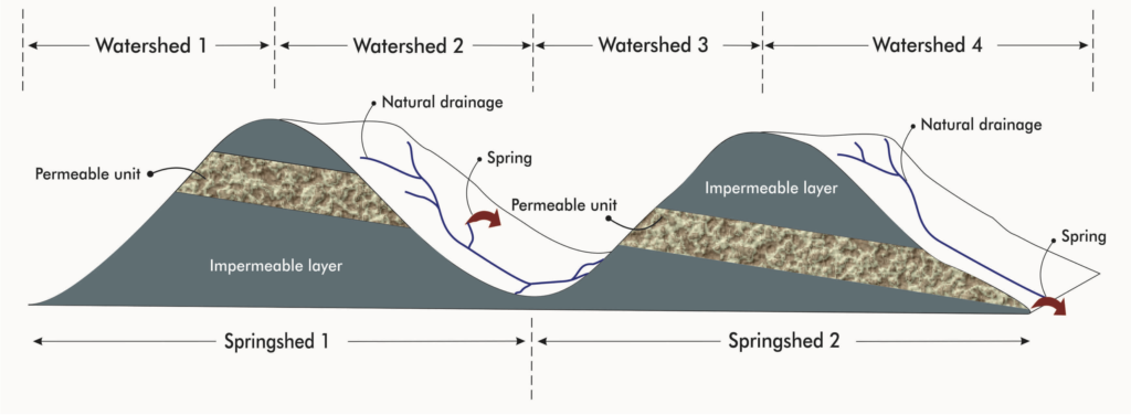
A majority of water conservation programs in the mountains have revolved around the concept of watersheds and watershed development, in the past. Watersheds are best described as the units of the land surface that drain water from the ridgeline to a common point into the valley through a system of interconnected stream channels. The watershed concept only accounts for surface water movement. Springsheds differ from watersheds because the source of spring water is determined by aquifer characteristics and not surface topography. Also, movement of spring water, which is groundwater, is determined by the underlying geology, that is, nature of rocks, their inclination and structure. The point where the spring emerges is based on the relationship of the aquifer to the watershed surface. A springshed is a set of watersheds and aquifers that integrate into a system that supplies water to a group of springs.

Spring inventory
To access the Spring inventory of the country, click here.
Knowledge resources
- Mobile Application mWater – Click here to Download
- Dhara Vikas programme handbook
Source : https://thespringsportal.org/
Last Modified : 3/31/2024
